Square Miles of Alaska
Alaska is the biggest state in the United States of America in terms of area in square miles. In fact, it is over twice the size of Texas, the second largest state. It is still bigger than the combined area of three large states namely Texas, California, and Montana, which are ranked 2-4. That is, if you combine the land area of Alaska with its territorial waters. It is also bigger than the combined area of 22 smallest states. Without Alaska, Brazil and Canada would have been bigger than America.
Alaska has a land area of 586,412 square miles. But in totality, square miles of Alaska amounts to 663,268.
Aside from its huge land area, Alaska also has the longest coastline than all the other states combined, about 34,000 miles. It is the only state in America that has coastlines on three different seas – the Pacific Ocean, the Arctic Ocean, and the Bering Sea.
Indeed, Alaska is a very big state!
A Look Through Alaska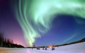
Alaska is about 55 miles away from the east of Russia. History has it that the territory was bought from Russia at a little over two cents per acre in 1867. At the price of $7.2 million, the land was turned into an organized US territory. Its statehood was declared in 1959. Officially, it was the 49th state of America.
There are only 698,473 residents living in Alaska, which are specifically located in the Anchorage metropolitan area. It ranked at number 48 in terms of population, with one person per square mile. The majority of residents in Alaska are White Americans while the African Americans, the American Indians, the Asian Americans, the Pacific Islander Americans, the Hispanics and Latinos, and the Alaska Natives made up the minority.
In terms of language, English remains the mostly spoken in all of Alaska. Spanish, Alaskan, Asian, and Native American languages are also spoken at home.
In terms of wealth, Alaska is at the 6th position among the US states, with only 8.5% unemployment rate
Alaska enjoys an oceanic climate. The highest temperature ever recorded was 38 degrees Celsius, tied with Hawaii at being the lowest high temperature among all the US states. The lowest temperature was -62 degrees Celsius, the second lowest temperature only next to what was recorded in North America.
The capital city of Alaska, which is Juneau is located in the Southernmost region. Unfortunately, like most of Alaska, it is not accessible by road travel. Alaska has very few road connections. Marine and air transport are far more useful if you like to take on a trip to parts of Alaska.
