How High is a Cirrocumulus?
The altitude or height of  cirrocumulus clouds range from 5 km to 12 km. That’s almost 6,000 meters or 20,000 ft. They belong to the Family A (high level) cloud types.
Physical Appearance of Cirrocumulus Clouds
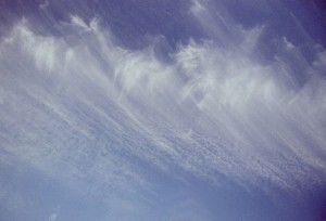
These clouds usually appear in rows. Like other clouds in the cumulus family, the cirrocumulus clouds denote convection. Convection in the atmosphere refers to the vertical movement of heat due to motion.
But unlike the other cirrus clouds, the cirrocumulus clouds have a small amount of water. However, the liquid water droplets are supercooled.
Composition of Cirrocumulus Clouds
Despite the height of cirrocumulus clouds, scientists have learned a great deal about their shapes and composition. The main ingredients are ice crystals.
In fact, it is the presence of ice crystals that lead to freezing. When freezing occurs, the cirrocumulus clouds undergo transformation; they change into cirrostratus clouds.
Cirrostratus clouds are distinguished from cirrocumulus by their hazy and uniform shape. This process also leads to the formation of virga. Virga refers to light wispy precipitation. Composed of ice and snow,
this precipitation usually dissipates before hitting the ground. Due to this chemical process, the lifespan of cirrocumulus clouds tend to be short compared with other cloud forms.
Cloudlets and Cirrocumulus
When discussing the height of cirrocumulus clouds and their properties, the term “cirrocumulus” should only be used on a particular cloud. However the term is generally employed for whole sections. In this case, the term cloudlet is designated for each cloud.
Other Characteristics
Cirrocumulus clouds are huge, white patches. Unlike other clouds, there is no gray shadow or color. The sizes of the cloudlets vary although some are no bigger than a finger. Invariably the clouds appear in sheets alongside other cirrocumulus clouds. Typical of other cumulus clouds, they appear in rows.
Due to the height of cirrocumulus clouds, the size and shape of the patches, it’s been called a mackerel cloud. The rippled look resembles the scales of a mackerel. This can also be indicative of stormy weather.
Difference between Cirrocumulus and Altocumulus Clouds
Because cirrocumulus and altocumulus clouds appear together, distinguishing between the two can be difficult. One of the main differences is the altitude; cirrocumulus clouds are higher. From the ground, this makes the cloudlets appear smaller.
Cirrocumulus clouds are also noted for being somewhat translucent. They also don’t have any shadows. Another element unique to cirrocumulus clouds is that they’re often metamorphosing into other cloud formations.
Altocumulus clouds on the other hand, resemble cotton balls. Their altitude is about 2.5 to 5.5. km or between 8,000 to 18,000 ft.
Formation of Cirrocumulus Clouds
Cirrocumulus clouds form when the cirrus clouds start to warm. This causes the air to rise and go into the clouds. The ice crystals are then transformed into water vapor. Altocumulus clouds on the other hand, are formed when moist air cools. It goes up and creates a cloud layer.
The height of cirrocumulus clouds and their composition can be engrossing to study. But even if you don’t know the technical aspects, just gazing into the clouds can be fascinating enough.


