Posts Tagged ‘country’

How Big is Japan?

Thursday, March 4th, 2010

An island country nicely situated within the eastern part of Asia, JapanJapan is often called the ‘Land of the Rising Sun.’ It is surrounded by the Sea of Okhotsk to the north, East China Sea to the south and the Sea of Japan to the east. It is comprised of 6,852 islands, the biggest of which are Shikoku, Kyushu, Hokkaido and Honshu. Worldwide, it is considered the 10th largest in terms of population, with more than 128 million people. Aside from these basic facts, there are other interesting things to learn about it including the size of Japan.

The Size of Japan

How big is Japan? In terms of total land area, Japan ranks 61st in the world, which measures 145,883 square miles or 377,873 square kilometers. Its capital city is Tokyo, which is also the largest in the country, measuring 2,187.08 square kilometers. Approximately 70 percent to 80 percent of the country is not suitable for use in residential, industrial and agricultural purposes because it is mountainous and forested.

Additional Facts and Other Interesting Details

The largest city in Japan is Tokyo, with an estimated population of more than 8,483,050. It is then followed by Yokohama, Osaka and Nagoya as the second, third and fourth largest cities in the country respectively. Sapporo is the fifth, Kobe ranks sixth and Kyoto owns the seventh spot. To complete the top ten biggest cities in the country are Fukuoka on the eighth, Kawasaki on the ninth and Saitama on the tenth spot.

Although the size of Japan is not that big compared to other highly progressive countries, it boasts of a strong, stable and progressive economy. In fact, it has the second largest economy all over the globe. It has a nominal gross domestic product of more than $5 trillion. Furthermore, it comes right after the United States and China when it comes to purchasing power parity.

The major industries in the country include real estate, insurance and banking. Aside from these, its economy receives major boost from telecommunications, transportation and retailing. In addition to its strong industrial capacity, it is also considered the most technologically advanced and biggest producers of machine tools, electronic equipment as well as motor vehicles. Although it has a shrinking labor force made up of more or less 67 million workers, its unemployment rate is very low, which is only around 4 percent.

Japan plays home to some of the biggest companies in the world like NTT DoCoMo, Nintendo and Toyota. Likewise, it also has other major business enterprises such as Nippon Steel, Sony and Honda. Moreover, this country also has a very strong export market, which includes China, the European Union and the United States.

What is the size of Georgia?

Saturday, January 9th, 2010

The total area size of Georgia is 59,425 sq m (equal to 153,909 sq km). GeorgiaIt is 298 miles (480 km) in length and 230 miles (370 km) wide.

Geographical Information

2.6% of Georgia’s area is water. The latitude is 34.985 degrees N with a longitude of 85.605 degrees W. Georgia’s highest point is Brasstown Bald at 4,784 ft (equivalent to 1,458 m). The lowest point is the Atlantic Ocean at 0 ft (0 m). The mean is 591 ft (180 m).

Its dimensions make Georgia the biggest state east of the Mississippi River (by land area). If water area is included the size of Georgia makes it the fourth biggest after Michigan, Florida and Wisconsin.

Population Size

Georgia’s population as of 2007 was 9,544,750. It was up by 180,809 from the previous year. The historical population growth of the city is as follows.

During 1790, the population figure was 82,548. In 1810 the population had reached 251,407 and 20 years later in 1830 had reached 516,823. By 1860 the figure had breached the 1 million mark (1,057,286). In 1880 the population size was 1,542,181; in 1900 the figure was 2,216,331.

During the 1920s, Georgia’s population was 2,895,832; by the 1940s it had reached 3,123,723. In 1950 it increased to 3,444,578, and in 1960 had gone up to 3,943,116. The 1980s saw the size of Georgia’s population reach 5,463,105. By 1990 the figure was put in at 6,478,216; in 2000 it was 8,186,453.

Demographics

The demographics of Georgia (as of 2000) shows 68.34% are white, 29.38% black and 0.66% American Indian / Alaskan Indian. 2.48% are Asian and 0.12% native Hawaiian. 7% are Latino. 90% of the population speaks only English.

5% can speak Spanish. 0.9% can speak French, 0.8% can talk in German and 0.6% can speak in Vietnamese. 2004 statistics indicate 8% of its population is below 5 years of age. 27% are below 18, and 8.5% over 65 years of age. 50% of the population are females, 30% of these are African Americans.

African American Population Size

Prior to the Civil War, almost half the size of Georgia’s population were comprised of African Americans. Even to this day, African Americans make up the bulk of the population in rural counties.

In terms of African American population percentage, Georgia is the third highest. It is next only to Mississippi and Louisiana. From 2006 to 2007, the state had a black population growth of 84,000, the largest in the US.

Climate

The weather in the state is characterized as humid subtropical. The summers are very hot, with the highest temperature reaching 112 F (44 C). The lowest is -17 F (-27.2 C). In terms of precipitation, it can range from 45 inches to 75 inches. The hot summers are marked by occasional thunderstorms during the afternoons.

Finally, the size of Georgia’s human population is matched by the diversity of its fauna and flora. There are 250 tree species, 58 plant types and 80 types of reptiles. There are also several types of fish and bird variants in the state.

How Big is Canada?

Thursday, December 31st, 2009

Located within the northern part of North America, CanadaCanada is considered the second biggest country in the world in terms of total land area. It is a constitutional monarchy and a parliamentary democracy, which considers Queen Elizabeth II as the head of state. Thanks to its diversified economy, it has now become one of the highly developed countries in the world. Aside from these important details, people can learn more about this country including the size of Canada.

The Size of Canada

How big is Canada? As the second largest country in the world in terms of land area, Canada measures 3,854,085 square miles or 9,984,670 square kilometers. Its capital city is Ottawa, while the largest is Toronto, which measures 243.2 square miles or 630 square kilometers. As one of the highly developed nations in the world today, it is a member of various international groups including the United Nations or UN, the Asia-Pacific Economic Cooperation or APEC and the Organisation for Economic Co-operation and Development or OECD.

Additional Facts and Other Interesting Details

Besides being a member of the UN, APEC and OECD, Canada is also part of the Commonwealth of Nations, the North Atlantic Treaty Organization or NATO and the Group of Eight or G8. It has two official languages, namely French and English. It is considered one of the wealthiest countries in the world. Add to that, it is also one of the top ten trading countries worldwide.

Canada has a very good national unemployment rate, with only 7.77 percent as of February 2009. It is also known as one of the net exporters of energy. In Alberta, the country has huge resources of gas and oil. Situated within the northeastern part of Alberta, the Athabasca Oil Sands give the country the second biggest reserves of oil in the world.

Canada is also one of the largest suppliers of agricultural products all over the world. For instance, the Canadian Prairies provide the country steady supplies of canola, wheat and other important grains. More importantly, it also produces different kinds of valuable natural resources like aluminum, nickel and gold. It is also considered the world’s biggest producer of uranium and zinc.

The largest city in the country is Toronto, which is then followed by Montreal, Vancouver and Ottawa-Gatineau as the second, third and fourth respectively. Calgary ranks fifth, Edmonton is sixth and Quebec City as the seventh biggest city in the nation. Winnipeg ranks eighth, Hamilton ranks ninth and London as the tenth biggest. As of 2006, the total population of the country is 31,612,897, which already increased by 5.4 percent from 2001.

What is the Size of America?

Sunday, December 27th, 2009

The size of America is 9,826,675 km2 (or 3,794,101 sq miles). Size of AmericaThe water area is 6.75%. Its population (2009 estimate) was 307,831,000. The density is 31/km2 or 90 sq mi. The capital is Washington D.C. The largest city is New York City.

Geographical Information

The contiguous land area is 1.9 billion acres (770 million hectares). The biggest state is Alaska at 663,268 sq mi (1,717,854 km2). The smallest state is Rhode Island at 1,545 sq mi (about 4,002 km2).

Alaska is equal to 365 million acres alone (150 million hectares). In terms of size, Hawaii is about 4 million acres (1.6 milion hectares). The coordinates are 33 degrees 00’ N and 97 degrees 00 W.

The entire country is about half the size of Russia. It is about 3/10 the size of the African continent. It is a little bigger than China and double the size of the European Union.

Population Demographics

The size of America’s population given earlier includes at least 11 million illegal immigrants. Its population growth is 0.8% and is the third most populated country after India and China. White Americans comprise 79% of the estimated population.

Hispanic Americans make up 15% followed by African Americans at 12.8%. Asian Americans make up 4.5% of the population. Multiracial races make up 1.7%. The rest are divided among Native Americans, Native Hawaiian, Alaska Native and Pacific Islander.

Population Centers

80% of Americans reside in urban areas, with 50% of the cities having populations of over 50,000. 273 incorporated places have populations exceeding 100,000. 52 metropolitan areas have populations exceeding a million. The sizes of America’s cities (as of 2008) are as follows.

New York City in New York has a population of 8,363,710, the most in the US. It is followed by Los Angeles, California with 3,833,995 while Chicago, Illinois is at number three with 2,853,114. The fourth most populated city is Houston, Texas with 2,242,193. At number five is Phoenix, Arizona with 1,567,924.

Philadelphia, Pennsylvania is at number six with a population of 1,447,395 followed by San Antonio, Texas with 1,351,305 residents. Dallas, Texas is at number eight with 1,279,910. San Diego in California is the ninth most heavily populated city with 1,279,329 and San Jose is tenth with 948,279.

Natural Features

The large area size of America has given it a very diverse topography and landscape. It has the Mississippi River, the fourth longest in the world. It goes from north to south in various states.

The Rocky Mountains reaches heights of over 14,000 ft (nearly 4,300 m). Mount McKinley in Alaska is the tallest mountain at 20,230 ft. the lowest point is Death Valley at -86 m. The arable land is 19% and the irrigated land measures 223,860 sq km.

Climate

Most of the country is temperate but some areas are tropical (like Hawaii). It is generally arid near the southwest. The northwest areas are noted for low temperatures during the winter season.
 
The size of America’s population and area is well matched by its ecology. There are 1,800 plant species, 400 types of mammals, 91,000 insect species 750 birds and over 500 reptiles.

How Big is Mexico?

Friday, December 25th, 2009

Officially called the United Mexican States, Mexico is Mexicoone of the nicest countries found in North America. It is surrounded by the United States to the north, the Gulf of Mexico to the east and the Pacific Ocean to the west and south. In the Americas, it is considered the fifth biggest country. Furthermore, it is also recognized as the 11th most populous nation worldwide, with an estimated population of more than 111 million as of 2009. Aside from these facts, there are other interesting things to learn about this place such as the size of Mexico.

The Size of Mexico

How big is Mexico? In terms of land area, Mexico ranks 15th in the world, measuring 761,606 square miles or 1,972,550 square kilometers. Its capital is Mexico City, which is also the largest city in the country with a total land area of 573.36 square miles or 1,485 square kilometers. It is the only Latin American country included in the Organisation for Economic Co-operation and Development or OECD. In terms of population, it ranks 11th in the world, with an estimated 111,211,789 residents as of July 2009.

Additional Facts and Other Interesting Details

Today, Mexico has the 11th best economy in the world. Although it experienced a severe economic crisis in 1994, it has now recovered fully by improving its macroeconomic fundamentals. Its economy is driven mainly by vastly improved modern industrial and service sectors, which feature rising private ownership. Some of its biggest economic contributors include natural gas distribution, electricity generation as well as telecommunications. Aside from these, it also has expanded competition in airports, railroads and ports.

Because of its export-oriented economy, over 90 percent of Mexican trade is under the terms of free trade agreements involving 40 other countries including Israel and Japan. In 1992, it signed the North American Free Trade Agreement or NAFTA together with Canada and the United States. In 2008, more or less 16 Mexican-based companies were included in the Forbes Global 200 list of the largest companies in the world.

From 1995 to 2002, the average growth rate of the annual gross domestic product in Mexico was 5.1 percent. In 2005, inflation hit a record low 3.3 percent. However, the country is not completely free from various kinds of economic concerns like inequitable income distribution, underemployment as well as low real wages. Furthermore, it is also concerned about its financial and commercial dependence on the United States. The leading industries in the country include financial services, construction and manufactured goods.

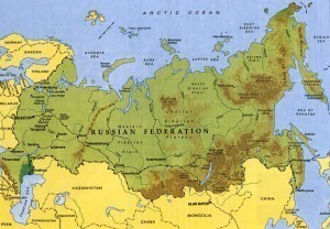
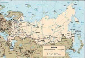
What is the Biggest Country?

Friday, December 25th, 2009

A term commonly used to refer to territory or a political division, a country can be used toBiggest Country talk about geographical as well as political entities. Countries differ on the culture, beliefs and traditions practiced by people living in these areas. Aside from these, the entities can also differ based on sizes. To enhance our understanding on geography, let us have a profile of the biggest country in the world.

Profile

What is the biggest country in the world? According to geography experts, Russia (also known as the Russian Federation) is considered as the biggest country. The area covered by this country is 17,075,400 square kilometers. This place shares borders with other nations including Finland, Norway, Poland, Estonia, Ukraine and Georgia. Additionally, the country has maritime borders with the United States and Japan. With a population of at least 142 million, Russia is known as the ninth largest country in the world.

Because of the large area covered by the country, it has 11 time zones and it has the largest resources for energy and mineral. Aside from these, the nation is known to have the biggest forest reserves. The climate in the country is influenced by several factors like the Indian Ocean’s warm air masses. The distinct seasons in the area are winter and summer. People in the area can still experience autumn and spring but for brief periods of time only.

The economy of the country is improving after it experienced different crisis in the 1990s. The factors that contributed to the economic growth in Russia are the rising oil prices as well as the increasing foreign investment. Another factor that affected the growth of Russian’s economy is the improving tourism in the country.

Some of the most famous tourist destinations are the Saint Petersburg as well as the Moscow. In the Saint Petersburg, tourists will find the topnotch museums Hermitage and Tretyakov Gallery. Aside from these, people can also find theaters in the area such as the Mariinsky and Bolshoi. In addition to these, tourists can find the popular churches in the world at Russia. These include the Cathedral of Christ the Savior, the Church of the Savior on Blood, the Saint Basil’s Cathedral and the Saint Isaac’s Cathedral.

Other popular tourist destinations in the country are the Palace Square, the Red Square and the Peter and Paul Fortress. When it comes to getting souvenirs and keepsakes, Russia is known for Matryoshka dolls, papaha warm huts and fur clothes.

How Big is Indonesia?

Tuesday, December 22nd, 2009

The Republic of Indonesia is a country that lies between the two Indonesiacontinents of Southeast Asia and Australia/Oceania. The country is composed of several islands totaling to 17,508 in number. It ranks fourth as the most populous country in the world with a population of approximately 230 million people. The majority of the people in Indonesia are Muslims thus ranks first as the country with the largest Muslim population in the world.

Land Area

Of the 17,508 islands in the Republic of Indonesia, only 6,000 of these islands are inhabited with people. Extending for 3,977 miles in between the Pacific Ocean and the Indian Ocean, the total surface area of the country is 1,919,440 square kilometers or 741,050 square miles including the ocean waters within the territory. This makes Indonesia the sixteenth largest country in the world according to land area.

The five largest islands of the Republic of Indonesia are Sumatra, Java, Kalimantan, Sulawesi, and New Guinea. The island of Sumatra covers 473,606 square kilometers of land area. The island of Java covers 132,107 square kilometers of land area. The island of Kalimantan covers 539,460 square kilometers of land area making it the world’s third largest island. The island of Sulawesi covers 189,216 square kilometers of land area. The island of New Guinea covers 421,981 square kilometers of land area.

Location

The Republic of Indonesia is considered to be one of the world’s largest archipelago. It is located between six degrees north latitude and 11 degrees south latitude. The entire archipelago spreads from 97 degrees to 141 degrees east longitude. The strategic position of Indonesia affects greatly the culture, politics, social, and economic status of the country.

The Republic of Indonesia shares land borders with the following countries: Papua New Guinea on the island of New Guinea, East Timor on the island of Timor, and Malaysia on the islands of Sebatik and Borneo. The country also shares borders over small straits of water with Malaysia, the Philippines, and Singapore on the north side and Australia on the south side.

Other Facts

The capital city of the Republic of Indonesia is Jakarta located on the island of Java. Jakarta is also the country’s largest city with the cities of Surabaya, Bandung, Medan, and Semarang following closely behind. The highest peak in Indonesia is Puncak Jaya with the height of 4,884 meters or 16,020 feet. The mountain is located in the island of New Guinea. In the island of Sumatra is found the largest lake of Indonesia called Lake Toba with a surface area of 1,145 square kilometers or 442 square miles. The largest rivers in the country are the Barito and Mahakam which are both located in the island of Kalimantan.

What is the Size of Australia?

Saturday, December 19th, 2009

The size of Australia is 7,617,930 sq km Size of Australia(2,941,299 sq mi). Its population as of 2009 was estimated to be 22,010,766. The density is 2.833 sq km or 7.3 sq mi. The capital is Canberra.

Geographical Information

The country has a coastline of over 32,200 km (21,620 mi). It also claims 8,148,250 sq km (3,146,060 sq mi) called the Exclusive Economic Zone. Off Australia’s northeast coast is the Great Barrier Reef, the Earth’s largest coral reef.

Mount Augustus is situated in Western Australia. Mount Kosciuszko is Australia’s highest mountain, rising up to 73,100 ft (2,228 ft). A great part of Australia is desert, referred to as the outback. Australia is the driest continent. Its soils are among the oldest on the planet.

The south west and south east corners have more temperate climates. However, the size of Australia allows for great variety on its landscape. On the northern section are lush forests, grasslands and some mangroves. The ocean also plays a role in determining Australia’s weather.

Population Growth

The earliest record of its population is from 1900. Back then there were only 3,765,300. It increased to 5,411,000 in 1920 and reached 10,392,000 by the 1960 census. There were 14,726,000 living in Australia by 1980 and 19,169,100 by the 1990s.

Largest Cites in Australia

The largest is Sydney with a population of 4,399,722. At number two is Melbourne with a population of 3,892,419 followed by Brisbane (1,945,639). At number four is Perth (population 1,602,559).

The population size of Australia’s Adelaide City is 1,172,105. Gold Coast is the 6th biggest with 558,888 residents. Newcastle is the seventh biggest with 531,191 and Canberra-Queanbeyan is at number eight with 395,126.

Wollongong is the ninth most populated with 284,169 and Sunshine Coast is at number ten (237,562). Hobart is at number 11 with 209,287 and Geelong at 12th spot with 172,300 residents. The population of Townsville is 162,730. Cairns’ population has been estimated at 142,001 and Toowoomba, 125,339.

Australian Territories and States

The biggest is the Australian Antarctic Territory at 5,896,500 sq km. Western Australia is next with an area of 2,529,875 sq km. Queensland is number three (1,730,648 sq km). The Northern Territory is the fourth biggest at 1,349,129 sq km. South Australia has an area of 983,482 sq km.

The size of Australia’s New South Wales is 800,642 sq km. the sixth largest is Victoria with an area of 227,416 sq km. Tasmania is the seventh largest at 68,401 sq km. Australian Capital Territory has been measured at 2,548 sq km. Ashmore and Cartier Island is the tenth biggest at 199 sq km.

Heard Island is the 11th biggest with an area of 144 sq km. Christmas Island is the 12th largest (135 sq km). Jervis Bay measures 70 sq km while Norfolk Island is 35 sq km. Cocos Islands measures 14 sq km and the Coral Sea islands 10 sq km.

The size of Australia’s population has been growing thanks to its robust economy. It is a member of the G 20 major economies, testament to its status as an economic power.

What is the Size of Africa?

Wednesday, December 16th, 2009

The area size of Africa is 30,221,532 km2Size of Africa (11,668,698.7 sq mi). The population is 1,000,010,000 as per 2005 estimates. The population density is 30.51/km2 or 80/sq mi. It is the second largest continent both in terms of size and population. It takes up 20% of the planet’s land area.

Natural Features

The elevation on average is 2,000 ft (600 m). The Sahara is the biggest desert in the world covering 9,000,000 km2 (3,500,000 sq mi). Its highest mountain is Mount Kilimanjaro at 19,340 ft (5,896 m), followed by Mount Kenya at 17,058 ft (5,199 m).

The third highest peak is Ruwenzori at 16,763 (5,109 m). The size of Africa’s landmass and its diverse resources is matched by its various types of fauna.

African Regions

The continent is divided into the following territories.

Eastern Africa

Eastern Africa has a total area of 6,384,904 km2. It includes the countries of Burundi, Comoros, Djibouti, Eritrea, Ethiopia, Kenya, Madagascar, Malawi, Mauritius, Mayotte, Mozambique, Réunion, Rwanda, Seychelles, Somalia, Tanzania, Uganda, Zambia and Zimbabwe.

Middle Africa

The total area is 6,613,253 km2. This region includes Angola, Cameroon, the Central African Republic, Chad, Congo, the Democratic Republic of Congo, Equatorial Guinea, Gabon and Sao Tome and Principe.

Northern Africa

Its area size is 8,533,021 km2. The territories are Algeria, Egypt, Libya, Morocco, Sudan, Tunisia, and Western Sahara. The Canary Islands, Ceuta and Melilla are Spanish territories in North Africa. The Madeira Islands are Portuguese territory.

Southern Africa

The size of Africa’s southern region is 2,693,418 km2. It includes the territories of Botswana, Lesotho, Namibia, South Africa and Swaziland.

Western Africa

The area size is 6,144,013 km2. The territories are Benin, Burkina Faso, Cape Verde, Côte d’Ivoire, Gambia, Ghana, Guinea, Guinea-Bissau, Liberia, Mali, Mauritania, Niger, Nigeria, Saint Helena, Ascension and Tristan da Cunha, Senegal, Sierra Leone and Togo.

African Countries by Population Size

The biggest in terms of population is Nigeria with 140,003,542 followed by Egypt with 80,335,036. Ethiopia is the third with its population of 75,067,000.

The Democratic Republic of Congo is fourth with 63,655,000; South Africa is fifth with 47,432,000 residents. Tanzania’s population has been estimated at 37,849,133; Sudan’s is 36,992,490 and Kenya, 34,707,817.

The size of Africa’s population in Morocco has been put at 33,757,175. The tenth most heavily populated is Algeria with 33,333,216. Uganda is 11th with 27,616,000; Ghana is 12th with 23,000,000.

Mozambique is 13th with 20,366,795 and Madagascar is the 14th biggest in terms of population with 18,606,000. At 15th place is Cameroon with 17,795,000 inhabitants.

The Biggest African Countries by Area

Sudan has an area of 2,505,813 km2 followed by Algeria at 2,381,740 and the Democratic Republic of Congo at 2,344,858 km2. Libya has an area of 1,759,540 while Chad has an area of 1,284,000 km2.

Niger’s total area has been measured at 1,267,000 km2 and Angola 1,246,700. Mali’s land area is 1,240,192 km2; for South Africa it is 1,221,037. Ethiopia’s land measures 1,104,300 km2.

The size of Africa’s population and resources notwithstanding, it remains the poorest of the continents. The reasons range from civil wars, tribal conflicts to government corruption.

How Big is Brazil?

Thursday, December 10th, 2009

The size of Brazil is 8,511,965 sq km in total. BrazilThe land area is 8,456,510 sq km and the water area is 55,455 sq km. It is on the northeastern side of South America and the Atlantic Ocean. It is half the size of the US.

General Characteristics

Brazil’s geographical coordinates are 10 00 S, 55 00 W. The country is bordered by Colombia (1,644 km), Bolivia (3,423 km) and Argentina 1,261 km. Other countries on Brazil’s border are French Guiana, 730.4 km, Peru 2,995 km, Paraguay 1,365 km and Guyana 1,606 km. The border with Suriname is 583 km. With Uruguay it is 1,068 km while the border with Venezuela stretches for 2,200 km.

Maritime and Coastline Territory

The size of Brazil’s coastline is 7,491 km. The maritime claim is 12 nm and the contiguous zone is 24 nm. The exclusive economic zone is at 200 nm and the continental shelf is 200 nm.

Geographical Facts

The lowest point is 0 m and the peak elevation point is Pico da Neblina at 3,014 m. The irrigated land has been estimated at 29,200 sq km. In terms of land used, the permanent crops comprise 0.89%. The arable area is 6.93%.

Climate and Terrain

The climate is generally tropical but it can be milder at the south. The size of Brazil has resulted in varied terrains. On the north, it is flat with some rolling plains. There are also mountains and hills along the coast. Brazil is also home to various natural resources.

Among them are petroleum, uranium, tin, platinum and nickel and ore. Among the natural hazards that occur in the country are floods in the south and drought at the north area.

The elevation is around 200 m (660 ft) up to 800 m (2,600 ft). There are numerous rivers in the country, most notably the Amazon. In terms of volume it is the biggest in the world.

Size of Brazil’s Population

As of 2009, the census put the total population at 191,241,714. The density is 22 sq km. The ethnic groups are composed of the following: 49.4% white, 42.3% brown, 7.4% Black, 0.5% Asian and 0.4% Amerindian. Brazil has the biggest population of Lebanese in the world, surpassing even those in Lebanon.

There are 25 million Italians in the country as well as 1.6 million Japanese. It should be noted that a majority of its population has mixed ancestry (European, American etc).

Most Populated Cities

At the top of the list is Sao Paulo with a population of 10,990,249. Rio de Janeiro is next with 6,161,047 followed by Salvador with 2,948,733. At number four is Brasília with a population of 2,557,158. At number five is Fortaleza (2,473,614) and at sixth place is Belo Horizonte with 2,434,642.

At number seven is Curitiba (1,828,092); at eight is Manaus (1,709,010) while at nine is Recife (1,549,980). Tenth is Porto Alegre (1,430,220).

The size of Brazil’s population is increasing also due to settlers and immigrants. The country has the most number of people with African blood outside of the African continent.