Hurricane Eye Diameter
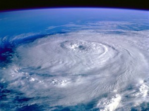
A hurricane is primarily a tropical cyclone, which  is also referred to as a tropical depression, a cyclonic storm and typhoon. It is characterized by heavy rain, strong winds and a massive low-pressure center. It is closely associated with thunderstorms. In the Southern Hemisphere, it usually follows a clockwise rotation. On the contrary, it rotates counterclockwise in the Northern Hemisphere. It features an eye, the diameter of which varies depending on its intensity. Aside from these details, there are other interesting things to learn about it such as the hurricane eye diameter.
The Diameter of a Hurricane Eye
Primarily circular in shape, the eye of the hurricane comes in varying sizes. Its diameter ranges from 1.9 to 230 miles or 3 to 370 kilometers. Upon reaching their peak, the eye usually contracts to an average diameter of 6.2 to 16 miles or 10 to 25 kilometers.
To determine the actual size of hurricanes, science experts rely heavily on the radius of outermost closed isobar or ROCI. A hurricane or cyclone is classified as midget or very small if it has a radius lower than 138 miles or 222 kilometers. An average-sized hurricane has a radius ranging from 207 to 414 miles or 333 to 666 kilometers. A hurricane is classified as very large in case its radius measures 552 miles or 888 kilometers.
Additional Facts and Other Interesting Details
The World Meteorological Organization has designated six different Regional Specialized Meteorological Centers in various parts of the world. These centers have the responsibility of providing hurricane advisories, warnings and bulletins in order to notify and alert the people. More importantly, they study and track the movements of tropical cyclones. For smaller regions, they rely heavily on the details that the Tropical Cyclone Warning Centers provide.
Aside from these organizations, various other institutions are available to provide tropical cyclone and hurricane advisories. These include the Canadian Hurricane Center, the Philippine Atmospheric, Geophysical and Astronomical Services Administration as well as the Joint Typhoon Warning Center of the United States. Cyclone Catarina was the first South Atlantic cyclone ever recorded. Eventually, it brought Category 2 winds that struck the southern parts of Brazil in March 2004.
The Meteorological Service of New Zealand and the Fiji Meteorological Service are responsible for monitoring the Southern Pacific area. Meanwhile, various institutions are monitoring the Australian region, namely the Papua New Guinea National Weather Service, Indonesia’s Meteorological and Geophysical Agency and Australia’s Bureau of Meteorology. Additionally, the North Indian Ocean is monitored closely by the India Meteorological Department.


