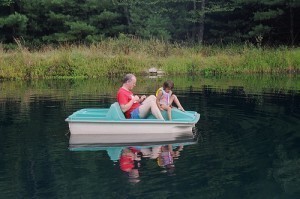
sea
Lake Michigan-Huron Dimensions
Lake Michigan-Huron is customarily
accepted as two lakes that are separate from each other. The two lakes are called as Lake Huron and Lake Michigan. They belong to the Great Lakes found in North America. But based on the hydrology of the two lakes, they show that they are just one body of water. They are connected together by the Straits of Mackinac.
Lake Dimensions
When specified as a single body of water, Lake Michigan-Huron will become the largest of all the Great Lakes nearby. The area of the lake is 45,410 square miles or 117,600 square kilometers. It is the world’s largest freshwater lake when it comes to surface area. The water volume of Lake Michigan-Huron is 2,000 cubic miles or 8,300 cubic kilometers. It makes the lake the world’s fourth largest freshwater lake when it comes to water volume.
One Lake?
Both Lake Michigan and Lake Huron have similar elevation of 176 meters or 577 feet. The two lakes are connected by Strait Mackinac that has similar elevation with the two. Mackinac Strait has a depth of 120 feet. It is pretty common that rivers and streams would separate lakes from one another. However, Mackinac Strait is not considered as a river or stream. The width of the strait ranges from 3.6 miles to five miles, similar to the lengths of most lakes in the world. By nature, the strait is just a natural narrowing of Lake Michigan-Huron. It is in oppose to the long time belief that it separates the two lakes from each other.
The water flow of Lake Michigan-Huron can be reverse from one lake to the other. Due to the connecting strait, when a water level imbalance happens, the two lakes can quickly even up the water level. Hydrologically, Lakes Michigan and Huron are truly one great lake due to the facts that they have similar water level and behavior.
The Name
Changing of historical names cannot be done that easily. The individual names of Lake Michigan-Huron are already distinct parts of the history. Aside from that, the names have been institutionalized legally between the territories that they fall under. Lake Michigan is considered to be under the American territory. Lake Huron is divided by two territories and they are the Canada and United States.
History
When the last ice age occurred, Lake Michigan-Huron is just more than one water body. Lake Huron of today is called by geologists as Lake Stanley and it is separated from Lake Michigan of today which is called by geologists as Lake Chippewa. During those times, Lake Chicago was occupying the southern end of the basin of Lake Michigan where the southern mass of the glaciers is present.
Tug Boat Sizes
The specifications given below should provide you
with some insights on the size and specs of tug boats. Before procuring one, it’s best if you talk to the manufacturer.
Tug Boat Dimensions: M/V Pacific Victory
The Pacific Victory is 150.0 ft long, 18.8 ft deep and has a breadth of 33.0 ft. The operating draft is 15.7 ft and 275 gross tons. It can accommodate a crew of ten. The fuel tank capacity is 182,000 gallons and the freshwater capacity is 6,000 gallons. For the lube oil it is 2,740 gallons.
The engine has 3900 horsepower at 900 rpm. The propellers measure 115 in x 90 in and come with four blades. The tow wire is 2000’ – 2 1/4”. The tow boat comes with SSB radio, GPS, fathometer, life raft, telephone and generator.
Tug Boat Dimensions: the 40’ Tug Boat Take Five
The Take Five’s length is 11,950 m / 39′ 2” and the beam is 4,095 m / 13′ 5". The depth is 3,366 m / 11′ 1" while the draft measures 1,043 m / 3′ 5". The displacement is 14.100 kg / 31.085 lbs. There is enough room for a dozen people.
The Take Five also has a saloon, wheelhouse and a cabin. The boat is equipped with a 200 horsepower engine. The cruise speed is 8 knots and has a maximum speed of 10 knots. The boat is also equipped with a bow thruster to make port entry easer. There are beds, closets and a shower. The boat can also be fitted with a washing machine.
Tug Boat Dimensions: the Selay 40
The length is 23.300 m and the breadth is 8.260 m. The depth is 3.680 m and has a complement of 7. The tank capacity is 80 m3 for MDO and 15.2 m3 for freshwater. The boat comes with a lifecraft, lifejackets and buoys.
The main engine is Cummings Inc. KTA38-M2. The power is 955 kw at 1800 rpm (1280 bhp). The reduction gear consists of two pieces of Reintjet WAF 562 (1/5.95). The propeller consists of two Wartsilla (2050 mm in diameter; 302 rpm and two Lips Hr-Nozzles). The equipment includes a radio telephone, a receiver, sounder and more.
Tug Boat Dimensions: the Luna
The length is 100 feet and the beam is 27 feet. The depth from the heel to deck is 18 feet and a fully loaded draft is 12 feet. When in light condition, the draft is 11 feet 4 inches. The full displacement is 325 tons and the light tonnage is 315 tons.
The crew can accommodate from 5 to 9 depending on the operation. The fuel capacity is 12,000 gallons of distillate diesel fuel. It is equipped with a couple of Winton Model 130 diesel engines with 6 cylinders at 300 rpm with 325 horsepower. Each one weighs 21 tons. There are also two generators.
Tug boat dimensions can get larger than those specified here. If you’ll need it for towing, talk with the manufacturer to get one that is the right size.
How Deep is Mariana Trench?
Situated right within the western Pacific Ocean, the Mariana
Trench is considered the deepest part of all the oceans in the world. It is a significant part of a system called the Izu-Bonin-Mariana Arc. From the Mariana Islands, people can find it somewhere on the east side. One of its notable features is the Challenger Deep, which is a small valley found somewhere at the floor of the southern end. In addition to these interesting facts, it is also nice to learn the depth of Mariana Trench.
The Depth of Mariana Trench
How deep is Mariana Trench? The maximum depth of Mariana Trench is 36,200 feet or 11,034 meters, which is found at the Challenger Deep. Its mean width only measures 43 miles or 69 kilometers, but its length is 1,580 miles or 2,550 kilometers. In case Mount Everest was set at the lowest point of the trench, almost 6,810 feet or 2,076 meters of water can be measured above it.
Additional Facts and Other Important Details
Through the Challenger expedition, the Mariana Trench was sounded for the very first time. It lasted from December 1872 until May 1876. It recorded a depth of 31,614 feet or 9,636 meters. After that, the Challenger II used echo sounding to survey the trench. This method was easier and more precise in measuring depth compared to the draglines and sounding equipment that were used during the first expedition. It measured a depth of 35,760 feet or 10,900 meters.
After that, a Soviet vessel named Vityaz surveyed the trench once again. This time, it came up with a different measurement, which was 36,200 feet or 11,034 meters. In 1962, the M. V. Spencer F. Baird surface ship used precision depth gauges, which measured a depth of 35,840 feet or 10,915 meters. In 1984, a highly specialized Japanese survey vessel called Takuyo was used to gather all-important data. With the help of a multi-beam echo sounder, it reported a depth of 35,798 feet or 10,911 meters.
In 2003, researchers from the Hawaii Institute of Geophysics and Planetology found another spot along the Mariana Trench similar to that of the Challenger Deep. Based on their reports, this spot could even be deeper. Their research ship towed a special sonar mapping system to survey the trench as well as the surrounding areas. The spot was later named the HMRG Deep, which was taken from the name of the group that discovered it. HMRG stands for the Hawaii Mapping Research Group.
On January 23, 1960, a Swiss-designed deep-diving research bathyscaphe named Trieste reached the lowest point of the trench. Swiss oceanographer Jacques Piccard and U.S. Navy Lieutenant Don Walsh were some of the notable individuals who were involved in that successful descent.
How Big is a Tsunami?
People have become quite interested in tsunamis due to their increased occurrences in
many parts of the world. Most generally understand it to be a really huge wave that can destroy coastal areas. However, there is more to a tsunami than what we have seen in the news. We’ll go over several common questions like how big is a tsunami, what it is, and how they are generated.
Defining a Tsunami
Before discussing how big is a tsunami, you should first understand what it is. A tsunami is not exactly just a huge wave that can destroy large coastal areas. It is more of a series of many waves that is characterized by a really long wavelength. It also observed to have a long time in between crests. Tsunamis are created when a large portion of seawater is displaced.
The time in between the crests of each wave in a tsunami can range from minutes even up to more than an hour. This means that sometimes after a big wave hits a second one may follow an hour or so later. There are those who incorrectly say that tsunamis are tidal waves. The truth is that tsunamis are not related to or are affected by the ocean’s tides.
How are they Generated
If you understand how they are generated you will have a general idea how big is a tsunami in relation to what caused it. As stated earlier, tsunamis are generated when there is a large displacement in the sea level. These can be triggered by landslides either going into or going under the surface of the water. Other causes include underwater volcanic activity and impacts made by meteorites.
How Big is a Tsunami
Understanding how big is a tsunami will require looking into the factors that affect it. A tsunami’s height varies from a few inches to as much as a hundred feet or more. You don’t get to notice it when you’re in a sheep sailing in deep water since it will only be three feet tall or even less. However, as it reaches shallow water it’s height becomes ever more impressive.
A tsunami’s height is therefore directly influenced by the features of the sea floor and the shoreline. Because of such factors, a tsunami can increase in height even up to ten times the original. A really huge tsunami can enter and flood low lying coastal areas even up to more than a mile away from the coast.
How Does It Look Like
When you’re at the shore with an incoming tsunami, you will either notice a tide that is quickly receding or a rapidly incoming one. There are some cases wherein it is observed that breaking waves are formed. Either way, these are the factors that influence how big is a tsunami. Understanding the factors that generate and influence it will help us understand why these waves may become really huge.
Dimensions of a Battleship
From World War I up to World War II, battleships were used
extensively by military forces. The following are some of the famous battleships used in combat.
Dimensions of Battleship Dreadnought (UK)
Launched in 1906, the Dreadnought had a length of 527 ft (161 m) and a displacement of 18,420 tons. The draught was 26 ft (7.9 m) and the beam 82 ft (25 m). The top speed was 21 knots (or 39 km/h). The complement was between 695–773. As the first ship to successfully use big guns, the Dreadnought changed the way battleships were designed.
Its weapons included 10 × BL 12-inch (304.8 mm) Mk X guns, 27 × 12-pdr 18 cwt L/50 MkI guns, Mk X guns and 5 twin B Mk.VIII turrets. The deck armor was 3 in (75 mm); for the turrets, 11 in (280 mm).
Dimensions of Battleship Scharnhorst (Germany)
One of the well known battleships of World War II, the Scharnhorst had a standard displacement of 31,552 tons. The maximum tonnage was 38,900. It was 235.4 meters (772 ft 4 in) long and had a beam measuring 30 m (98 ft 5 in).
The draft was 9.93 (or 32 ft 7 in). The top speed was 3 knots (61 km/h) and the range was 10,100 mi. The complement of the Scharnhorst was 1,968. They were comprised of 60 officers and 1,909 enlisted personnel.
Its weapons included 9 × 28 cm/54.5 (11") SK C/34 guns, the 12 × 15 cm/55 (5.9") SK C/28, the 14 × 10.5 cm/65 (4.1") SK C/33 and the C/38.
Dimensions of Battleship Missouri (US)
The last battleship constructed by the US, the Missouri was 887.2 ft (270.4 m) long and had a displacement of 45,000 tons. The draft was 28.9 ft (equal to 8.8 m) and the beam was 108.2 ft (or 33.0 m). The top speed was 33 knots (61 km/h) and had a complement of 2,700.
Its arsenal consisted of the 9 × 16 in (410 mm)/50 cal Mark 7 guns, the 80 × 40 mm/56 cal anti-aircraft guns and the 20 × 5 in (130 mm)/38 cal Mark 12 guns.
Secondary weapons included 49 × 20 mm/70 cal anti-aircraft cannons. The armor belt was 12.1 in; the bulkhead was 11.3 in and the turret armor was 19.7 in.
Dimensions of Battleship Wisconsin (US)
The battleship was 887.2 ft (270.4 m) long. The beam was 108.2 ft (33.0 m) and the draft 28.9 ft (8.8 m). The maximum speed was 33 knots (61 km/h). The displacement was 45,000 tons. The complement was 1,921.
Its main weapons during World War II were the 9 × 16 in (410 mm)/50 cal Mark 7 guns, the 80 × 40 mm/56 cal anti-aircraft guns and the 49 × 20 mm/70 cal anti-aircraft guns.
Prior to being retired the battleship Wisconsin saw action in World War II and the Korean War.
The dimensions of battleships made them powerful weapons. However they were superseded by aircraft carriers and are no longer used in battle.
How Deep is the Pacific Ocean?
Known as the largest ocean in the world, the Pacific Ocean is
bordered by the Arctic Ocean at the north, Antarctica at the south, North and South America at the east as well as the Australia and Asia at the west. The total area covered by this body of water is 169.2 square kilometers. The equator divides the ocean into two, namely the North Pacific Ocean and the South Pacific Ocean. The deepest point of the ocean is the Mariana Trench. To know about the geography of this body of water, let us start with identifying its depth.
The Depth of the Pacific Ocean
How deep is the Pacific Ocean? The ocean has a mean depth of 14,000 feet and its deepest point lies 35,979 feet below sea level. The southern part of the body of water extends 9,600 miles from the Arctic’s Bering Sea to the Ross Sea of the Antarctica. The ocean also stretches 12,300 miles from the coast of Peru as well as Colombia to Indonesia. The Strait of Malacca is the ocean’s western limit. The size of this body of water is decreasing by two to three centimeters a year on three sides. This is due to plate tectonics.
Additional Facts and Other Interesting Details
The ocean has approximately 25,000 islands. Most of the islands are located at the equator’s south. The ocean is surrounded by some of the largest seas in the world including the East China Sea, the Celebes Sea, the Philippine Sea, the South China Sea and the Sea of Japan. The Strait of Malacca as well as the Indians Ocean integrates with the Pacific Ocean at the west. The Straits of Magellan and the Drake Passage connects the Atlantic Ocean with the Pacific. At the north, the Arctic Ocean and the Pacific is connected by the Bering Strait.
The most essential regional distinction in the ocean is the andesite line. The line separates the Central Pacific Basin’s mafic igneous rock from the felsic igneous rock. The other features of the ocean are troughs, oceanic volcanic islands as well as submerged volcanic mountains. The Pacific Ring of Fire is composed of active volcanoes found at the subduction zones of the ocean.
Aside from volcanoes, the ocean also features seamount chains like the Louisville seamount chain, the Emperor Seamounts as well as the Hawaiian islands. Additionally, there are landmasses found within the ocean. These include the New Guinea islands and Polynesia’s great triangle.
How Big is a Catfish?
Considered as one of the ray-thinned fishes, the catfish got its name
from its prominent barbels, which are very much similar to the whiskers of cats. It comes in different sizes, some of the most notable species of which are the candiru, the wels catfish of Eurasia as well as Southeast Asia’s Mekong giant catfish. It is widely used as a cooking ingredient, specifically in places like North America, Europe and Asia. In addition to these highly interesting details, it is good to know the sizes of a catfish.
The Different Sizes of a Catfish
Ordinarily, a catfish can grow up to 12 centimeters. However, small species like the Trichomycteridae and the Aspredinidae mature sexually at only about 0.39 inches or 1 centimeter. Silurus glanis is another species, which is native in Europe. The average size of this kind of fish is 3.9 feet to 5.2 feet or 1.2 meters to 1.6 meters. One of the largest ever recorded under this species measured approximately 8.2 feet or 2.5 meters long.
In May 2005, the biggest Ictalurus furcatus was caught somewhere in the Mississippi River, which weighed 56 kilograms or 124 pounds. Meanwhile, the biggest Pylodictis olivaris or flathead catfish ever recorded was caught within the waters of Independence City in Kansas. It weighed 56 kilograms or 123 pounds and 9 ounces. A British schoolgirl caught a whopping 193-pound catfish within the River Ebro in Spain in July 2009. However, the biggest catfish ever recorded so far was the giant Mekong catfish that was caught in the northern part of Thailand in May 2005. It weighed 650 pounds or 293 kilograms.
Additional Facts and Other Important Details
In terms of external anatomy, a catfish has a bony head and reduced gas bladder, which allows it to sink rather float in water. Combined with a fully developed Weberian apparatus, the reduced gas bladder gives it the ability for enhanced sound production as well as hearing. Half of the catfish families have sexual dimorphism. Most of the catfish species are cystovarian in nature, specifically Loricaria lentiginosa, Lophiosilurus alexandri and Pseudoplatystoma corruscans.
Catfish is caught and farmed in many different places, particularly in North America, Asia and Africa. In the United States, two of the widely farmed species are the blue catfish and the channel catfish. It is good to eat this kind of fish because it serves as a very good source of omega-6 fatty acids and vitamin D. However, it only contains low to moderate omega-3 fatty acid levels.
What is the Lowest Lake?
Statistics of the Lowest Lake
The Dead Sea is the lowest lake of the world.
It may be called a sea but it is considered as a lake. Actually, it is a salt lake found that borders between Israel and Jordan. The shores as well as the surface of the lake have the measurement of 1,385 feet or 422 meters below the sea level. It is considered as the lowest elevation on the world’s surface that belongs to the dry land.
As the lowest lake in the world, the Dead Sea also has a maximum depth measurement of 1,240 feet or 378 meters. It is in fact the deepest salt lake of the world. It is also among the saltiest water bodies in the world because it has a salinity of 33.7%. Compared to the ocean, this lake is 8.6 times saltier. The saltiness of the water makes the lake a severe environment since nothing can literally survive on it.
The length of the Dead Sea is 42 miles or 67 kilometers and the width is 11 miles or 18 kilometers at the widest point of the lake. The lowest lake is lying in the place called Jordan Rift Valley where the Jordan River is its major tributary. The surface area of the lake is 810 square kilometers or 310 square miles. The water volume of the Dead Sea is 147 cubic kilometers or 35 cubic miles.
Therapies and Health Effects
The area of the Dead Sea has developed into a major focus for researches in relation to health and treatment. The various characteristics of the lowest lake have become the important factors of these researches. The water of the lake has lots of mineral content. The atmosphere surrounding the lake has very low content of pollens and other kinds of allergens. It also has a very low component of ultraviolet for solar radiation. At this depth of the lake, the atmospheric pressure is high and researchers are also studying it for specific health effects on individuals.
The climate of the Dead Sea area and its low elevation had turned the lake into a very famous place for various kinds of therapies. Climatotheraphy, Thalassotheraphy, and Heliotheraphy are among the popular therapies done in the lowest lake on Earth.
Human Communities
Near and around the Dead Sea are various human communities and among these are the settlements of the West Bank Israeli. At Ein Gedi is a nature preserve that is truly beautiful. There are hotels found within the southwest end of the lake at the place called Ein Bokek close to Neve Zohar. On the Israeli side of the lake, Highway 90 is the major road that runs from north to south. On the Jordanian side of the lake, the major road is Highway 65 that runs also from north to south. There is also a small town here called Potash City.
How Deep is the Arctic Ocean?
Known as the shallowest and the smallest oceanic
division in the world, the Arctic Ocean is situated at the Northern Hemisphere. This body of water is surrounded by North America and Eurasia. Sea ice covers some parts of the ocean. The salinity and the temperature of the water of the ocean change every time the sea ice freezes and melts. Aside from this, water temperature and salinity are also affected by low evaporation and heavy water flow from streams and rivers. To have ideas about the geography of the Arctic Ocean, let us look at the depth of this body of water.
The Depth of the Arctic Ocean
How deep is the Arctic Ocean? The ocean’s mean depth is 3,410 feet. The deepest part of the Arctic is found in the Eurasian Basin. It has a depth of 17,900 feet. The ocean is popular for the Lomonosov Ridge, which separates the North Polar Basin into two, namely the Amerasian Basin and the Eurasian Basin.
The Amerasian Basin (also known as the Hyperborean Basin or the North American Basin) has a depth of 13,000 feet. The Amerasian Basin and the Eurasian Basin are divided by numerous ridges. The ridges formed various basins including the Makarov Basin, the Canada Basin, the Fram Basin and the Nansen Basin. Some of the major tributaries to the Arctic Ocean are the White Sea, the Greenland Sea, the East Siberian Sea, the Hudson Strait, the Laptev Sea, the Hudson Bay and the Beaufort Sea.
Additional Facts and Other Interesting Details
The Arctic Ocean is abundant in natural resources. Some of the resources that are present in the ocean include natural gas fields, petroleum gas fields, polymetallic nodules, placer deposits, gravel and sand aggregates, seals, fishes and whales.
Many countries such as the United States, Denmark and Norway have disputes related to the political dead zone found just several miles from the center of the Arctic because it is possible that the zone holds 25 per cent of the undiscovered gas and oil resources in the world. When it comes to marine species, the ocean plays home to endangered animals like whales and walruses. Phytoplanktons are essential to the survival of species living in the ocean.
The Arctic Ocean is also popular for major harbors and ports found within this body of water. Some of the famous ports and harbors are the Longyearbyen in Norway, Prudhoe Bay in the United States, Tuktoyaktuk in Canada and Dudinka in Russia.
How Long is the Nile River?
Known as the longest river in the world, the
Nile River is a popular and major river that passes through the different countries in Africa including the Democratic Republic of Congo, Ethiopia and Egypt. The river has two tributaries, namely the Blue Nile and the White Nile. The Blue Nile is longer than the second tributary. The White Nile flows from the Great Lakes to the Lake Victoria, Tanzania and Uganda. To know more about this river, it is best to determine the length of the Nile River.
The Length of the River
How long is the Nile River? The length of the river is 6,650 kilometers. The drainage basin measures 3,400,000 square kilometer while the average discharge level is 2,830 cubic meter per second. Aside from the Blue Nile and the White Nile, another tributary to the river is the Atbara River. This river begins at the north portion of the Lake Tana in Ethiopia. The river is not that prominent because it only flows whenever there is rain. Additionally, the river dries fast.
At Mongalla, the Nile River is known as the Albert Nile and the average flow rate is 37,000 cubic foot per second. The river enters the swaps found in Sudan’s Sudd region and known to people in the area as the Bahr El Jebel. Its average flow rate is 18,000 cubic foot per second. From the swamps, the river joins the Sobat River, known as the White Nile.
The two essential tributaries to the White Nile are the Sobat River and the Bahr al Ghazal. Bahr’ al Ghazal’s drainage basin measures 520,000 square kilometers. The other river joins the White Nile near Lake No and it contributes 412 cubic meters per second yearly to the Nile. The mean flow rate of the White Nile at Malakal is 32,600 cubic foot per second. In early March, the flow rate of the river is 43,000 cubic foot per second while the rate in late August is 21,500 cubic foot per second.
The Blue Nile contributes 80 per cent to 90 per cent to water discharge of the Nile River. The Blue Nile’s peak flow exceeds 200,000 cubic foot per second. Before dams were constructed along the river, the peak flow of the river exceeds 290,000 cubic foot per second while the minimum flow is estimated to be 19,500 cubic foot per second. The level of water discharge is influenced by several factors including evapotranspiration, diversions, weather as well as groundwater flow.


