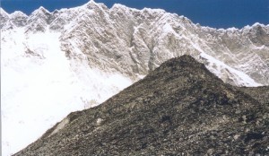
How High is Mount Merapi?
Mount Merapi is translated into Indonesian language as Gunung Merapi, which literally means  Mountain of Fire. It is found on the border between the Indonesian provinces of Yogyakarta and Central Java. Amongst the group of volcanoes found within the southern part of Java, the youngest is Merapi. It is part of the Pacific Ring of Fire, which is one of the 129 volcanoes that are active in Indonesia. In addition to these important facts, you can find out more about this place including the height of Mount Merapi.
The Height of Mount Merapi
How high is Mount Merapi? This stratovolcano measures 9,738 feet or 2,968 meters. In 1994, a large explosion happened, which killed about 64 people. In 2006, an earthquake in Yogyakarta preceded a massive eruption. Aside from these, there were other notable eruptions in the past, one of which happened in 1006. Based on reports, ash covered the central parts of Java. This particular eruption was so devastating that it eventually led to the fall of the Hindu Kingdom of Mataram.
Additional Facts and Other Important Details
Mount Merapi experienced increased seismic activity in April 2006. This sign showed that new eruptions were bound to happen. Neighboring villages were placed on high alert, while residents were evacuated. By April 19, the crater emitted smokes of up to 400 meters in height. On April 23, more than 600 infants and elderly were evacuated after almost 156 multifaceted quakes and 9 surface tremors.
By the first few days of May, active flows of lava started. By May 11, the flow of lava became constant. The highest alert status for earthquakes was released. Residents living close to the mountain were ordered to evacuate right away. Many villages did not heed the warnings because they feared that their possessions were subject to theft. By the middle parts of May, volcanic activity calmed down a bit.
In the closing days of May, an earthquake with a 6.2 magnitude struck the southwestern part of Merapi. This particular event left more than 200,000 people without homes and more than 5,000 individuals dead in the region of Yogyakarta. The earthquake heightened the possibility of a major eruption. By June 6, more than 11,000 villagers more left the area as superheated gas clouds and lava flowed out of the volcano.
Until now, the mountain is still part of an active volcano-monitoring program. The monitoring of seismic activities in the area started since 1924. Monitoring stations are positioned in various areas like Plawangan, Selo and Babadan.